Infrastructure Climate Resilience Projects
Central government’s Budget in 2020 included $210 million for climate resilience and flood protection projects across New Zealand. This funding formed part of government’s response to the economic impacts of COVID-19. Horizons Regional Council received $26.9 million of this funding via Kānoa, the government’s Regional Economic Development & Investment Unit, for projects designed to increase communities’ resilience to the effects of climate change.

Getting this funding enabled us to accelerate this work and create employment opportunities across the region. This means the projects will not only help to keep our communities safer from the impacts of climate change, but also helped to boost the region’s economy as work on maintaining and building new infrastructure progressed.
There were four suites of work completed as part of the Infrastructure Climate Resilience Projects mahi: Palmerston North Stopbanks, Lower Manawatū Scheme, Rangitīkei River Climate Resilience, and Te Awahou Foxton Flood Mitigation Project.

Palmerston North Stopbanks
We upgraded a range of stopbanks and assets throughout Palmerston North.

Lower Manawatū Scheme
Improvements were made along a key stretch of the Manawatū River, including to the Moutoa floodgates.

Rangitīkei River Climate Resilience
Working with the Rangitīkei River to create a more economically and environmentally resilient approach to river management

Te Awahou Foxton Climate Resilience
Collaborations with iwi, Horowhenua District Council and others led to improved resilience for Foxton.
Palmerston North Stopbanks
The Manawatū River is a highlight of living in Papaioea Palmerston North. Flowing through the eastern side of the city, significant work has taken place over the years to connect residents to the awa. The same can be said of the Mangaone Stream, which weaves through the city from Flygers Line to Pioneer Highway before it joints the Manawatū River. Both waterways have easily accessible walkways alongside them for people to enjoy.
While easy access to these waterways is an advantage, it comes with the risk of flooding and the associated cost of protection. We have invested heavily for decades to safeguard the city’s residents and protect the billions of dollars’ worth of housing, businesses and public assets from flood events along the Manawatū River and Mangaone Stream
The Palmerston North Stopbanks Climate Resilience project focuses on planning, investigating, designing, and constructing improvements to flood protection across the city. These initiatives were identified as necessary in a 2019 report by Tonkin & Taylor, which highlighted areas needing enhanced climate resilience.
Initial work for this project began in mid-2021 with an assessment of the current state of stopbanks, including a CCTV investigation of Palmerston North City Council stormwater outlets where they pass under our stopbanks to determine the state of infrastructure.
Albert Street
The Albert St entrance to the Manawatū River Shared Pathway is one of the most popular access points to the Manawatū River in Papaioea Palmerston North. Palmerston North City Council has done significant work to improve the amenity of the area.
The stopbank on the true right of the awa in this area provides protection to the pathway, a main water line and a large portion of the Hokowhitu suburb. If this stopbank was to fail, many homes in Hokowhitu would be at risk of flooding. To improve climate resilience, we constructed a 210-metre-long rock lining.
|
|
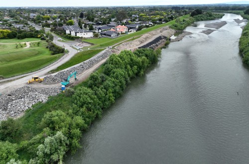
This project was completed in April 2024.

Scrap metal recovery
During the project, we removed 120 tonnes of scrap metal from the riverbank.
The origin of this metal and how got into the bank is not yet clear, but removing it was a bonus outcome of the project.
Lower Manawatū Scheme
The Lower Manawatū Scheme covers a vast area, including the Manawatū River from Papaioea Palmerston North to the see, the Ōroua River from Aorangi Feilding to the Manawatū confluence, the Mangaone Stream from Bunnythorpe to the Manawatū confluence, the Tokomaru River near Shannon, and various small streams and drains which drain into those larger streams and rivers.
Horizons has invested heavily into assets throughout the scheme to provide protection for homes, businesses and assets near these waterways. Since the 2004 floods which caused widespread damage across the region, work has included raising and rebuilding stopbanks, replacing the Kopane Bridge, and the construction of the Burkes Pump Station. Funding constraints have hindered additional work. However, the funding from central government enabled more work to be done.
Moutoa floodgates
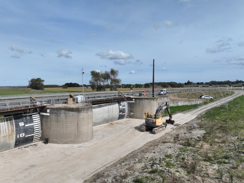
After more than six decades of service with minimal upgrades, an investigation into the condition of the gates revealed some electrical, mechanical and structural upgrades were required to ensure effective and successful operation of the floodgates.
Upgrades began with the successful installation and switch-over to a new electrical system in October 2024. The remaining upgrades included the installation of new mechanical components and new overhead lines being installed to make it easier to undertake maintenance. Flood modelling was also completed to assess potential impacts of more severe flooding and determine necessary flood contingency plans should adverse weather hit the area while upgrades are underway.
Mangaone Stream protection improvements
Residents along the Mangaone Stream near Tremaine Ave benefit from protection from flood events provided by gabion baskets and stopbanks. However, the gabion baskets are deteriorating and need to be replaced to maintain effective protection.
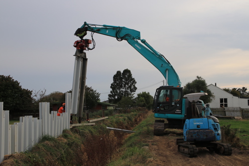
A secant pile retaining wall is being built behind the gabion baskets. We will remove the gabion baskets once the retaining wall is complete. This method ensures continued protection for the stopbanks throughout the construction phase.
This initiative is an important step in providing climate resilience and ensuring sustainable protection for the community and the surrounding areas along the Mangaone Stream.
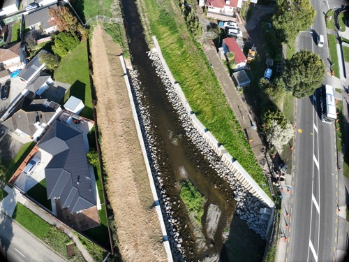
This project was completed in mid-2025.
Other works as part of this project
Belvedere Cres stopbank upgrade
Replacement of timber retaining wall at Bisley St
Realignment of the Kākātangiata stopbank
Removal of poplar trees shading sections of the Manawatū River bridal path.
Te Matai Road rock armouring
The stopbanks along the Manawatū River near Te Matai Rd between Palmerston North and Ashhurst are rated for a 1-in-100 year flood.
These stopbanks protect more than 360 hectares of agricultural and horticultural land, as well as homes and businesses. However, the awa was slowly eating away at the riverbank near a bend in the river, getting closer to the stopbanks.
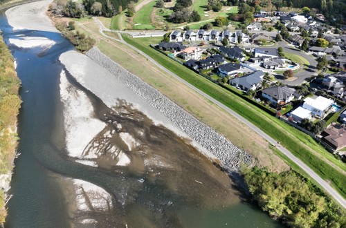
The scope of work was to try to deflect the river around the bend in a way which was not going to cause erosion. We achieved this by placing 440 metres of armouring rock (riprap) along the true right side of the river. This effectively tied together two existing sections of armouring further up and down the river. We also upgraded a section of stopbank in this area.
Construction began in November 2022 and was slightly delayed due to cyclones Hale and Gabrielle. This project was largely completed towards the end of 2023.
Other works as part of this project
Hartley Street rock armouring at Foxton Beach
Tokomaru stopbank reinforcement
Design of a new Rangiotu floodgate
Koputaroa stopbank construction.
Rangitīkei River Climate Resilience
The Rangitīkei River has changed significantly over time. This started with clearing the banks for farming and planting of exotic vegetation. More recently, hard engineering was used to control river alignment, protecting infrastructure and productive land.
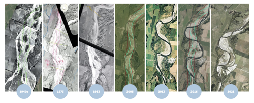
The Rangitīkei River Climate Resilience Project focused on creating a more economically and environmentally resilient approach to river management downstream of the Bulls Bridge. The overall aim is to give the awa more room to move by widening its corridor, increasing its capacity to absorb larger flood events and allow for natural dynamic changes.
Mobility corridor - a new way of working with the river
This approach to river management, called ‘a mobility corridor’ or ‘room for the river’, defines a corridor in the river flood plain where engineered solutions are not the only way to control erosion or river flow. This recognises a health river is highly dynamic, continuously adjusting its path and changing due to various circumstances.
For the Rangitīkei River, our intention is to create a mobility corridor which will enable the river to flow more naturally and, when it is in flood, disperse water across a wider area. This will provide protection to the stopbank network and other infrastructure. The mobility corridor boundaries are positioned to take advantage of, and reflect, natural geological features and controls (e.g. hard mudstones) as well as private land and existing infrastructure (e.g. stopbanks).
Associated works
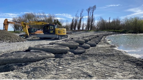
Addressing the risk of erosion against the Parewanui stopbank by widening the channel through the removal of non-native vegetation (both mechanically and with aerial spraying).
Gravel management.
Repairing engineered assets, such as the Scotts Ferry rock lining.
Planting out pastoral land alongside the awa, creating a native plant corridor.
Some of this work involves putting some Horizons leased land back into native vegetation to protect the stopbank.
Some of this work also has benefits beyond climate resilience against flood events. The native planting and wetland creation will enhance the ecological value of the river environment and improve water quality
There have also been wider social benefits. The work has provided employment and training opportunities to local businesses and iwi, while we have also created new amenity for communities. For example, upgrades have been completed to the Scotts Ferry access pathway.
Te Awahou Foxton Flood Mitigation Project
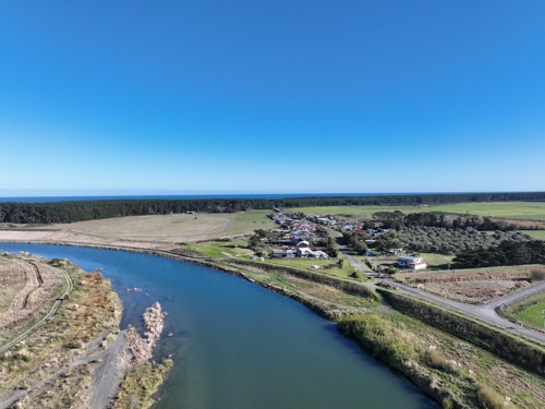
Te Awahou Foxton has historically been affected by flooding on a regular basis. To this day, the township regularly experiences flooding due to localised heavy rain events. This causes disruption and damage, negatively impacting the lives of people living in the town.
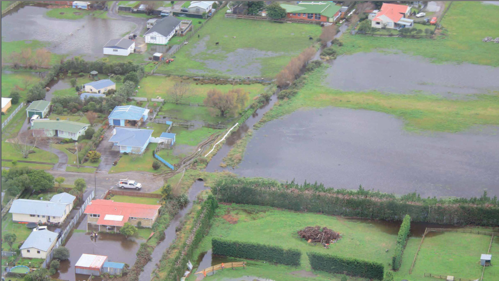
Foxton has flood protection estimated to be 1-in-2 to 1-in-5 year protection. There are a range of drainage and flood protection assets in and around the township. However, there are limits to the current level of services provided by private, Horizons, and Horowhenua District Council assets.
The Te Awahou Foxton Flood Mitigation Project aimed to address the persistent flooding issues in Foxton township, caused by overtopping and seepage from the Foxton East Drainage Scheme. The exact works proposed changed over time, with a range of factors – not least the Covid-19 pandemic – impacting the project.
A governance group was established in 2024, featuring representation from Horizons, Horowhenua District Council, iwi, hapū, and others in the community. The aim of the governance group is to work collaboratively to ensure solutions work for the community and local environment. The group is taking a fresh approach, ensuring they deliver tangible solutions for residents and landowners.
Works completed:
Sheet piling along the true right bank of King’s Canal between Avenue Rd and Cook St. This will mitigate seepage and reinforce the current bank.
The order of temporary tractor pumps. The intent for these is to provide for the removal of surface water from Purcell St during rain events when water cannot flow to Piriharakeke Manawatū River loop due to tidal influences.