
Building community resilience River Management
Providing flood resilience to keep our communities safe is something we take very seriously, and which forms a major part of our business as a regional council. We do this through our river management programme, which allows us to help prevent floods and provide adequate land drainage where necessary.

Managing our region's rivers
The river management team at Horizons is responsible for maintaining the river and drainage systems in the region to minimise erosion and ensure optimum flood resilience for our communities.
With many urban communities located on flood plains, it is important to have an appropriate standard of flood risk mitigation for the safety of the community. The protection of the flood plains is also important for protecting productive land, which is important to the economic goals of the immediately affected areas as well as the wider region.
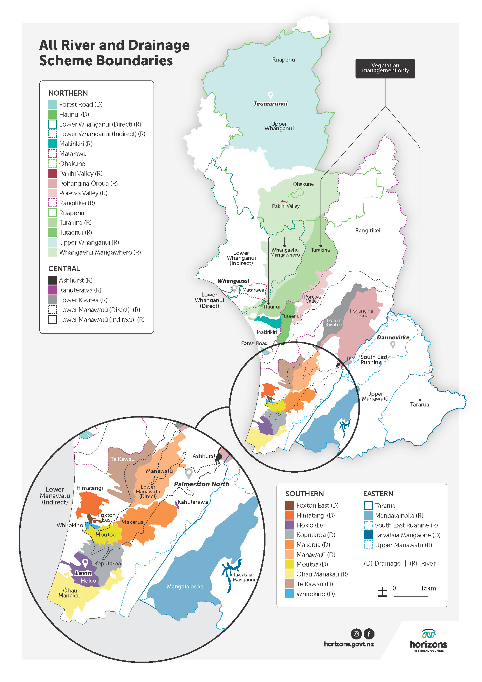
Horizons currently manages 34 river and drainage schemes across our region, maintaining over 506 km of stopbanks, 755 floodgates, over 800 km of river channel, and more than 1,100 km of drains.
River and Drainage Schemes
A scheme is a designated area of land that receives protection from flooding, riverbank erosion and channel movement, and can also include land drainage services. Currently, 71,000 hectares of land and 10 urban areas are included within scheme areas.
Rates and river management
All ratepayers in the region contribute to river management works for flood resilience. However, those who live within a scheme area pay an additional direct rate for the protection they receive. Flood resilience is funded through both general rates and also scheme rates, which is based on the amount of protection benefit each ratepayer receives.
Interested in extracting gravel?
Complete and submit the Application to utilise Land Use Consent form below to show your interest in extracting gravel in the next financial year.
Forms are due before 31 May each year, these will be assessed and allocations made in June for the coming financial year. Applications cannot be carried over more than one year. An application does not guarantee allocation.
Application to utilise Land Use Consent
Scheme boundaries

Nature-based Solutions in the Pohangina and Ōroua rivers
We recently conducted a feasibility study, using funding from Ministry for the Environment under the Nature-based Solutions for Resilience Planning programme, to investigate a 'Room for the River' approach to river management in the Pohangina and Ōroua rivers. Find out more about this study and the findings here.
Planned works
View a map of upcoming planned river management works for the upcoming month below.
This map shows planned engineering works for river flood and drainage scheme maintenance, repair and capital projects, and is refreshed monthly. For enquiries about planned engineering works, please contact us.
The location and timing of planned works for the month ahead is indicative as these are dependent on variables that can change such as weather, contractor availability, and other reactive work priorities that arise. Reactive works occurring during a month, such as that in response to urgent damage, will be added to the report at the end of the month.
View a larger version of the data table and map.
Non-scheme advice and works grants
Don’t live in a scheme area? We can assist with river and drainage engineering advice or through environmental grants to complete relevant river engineering works.
To ensure people’s needs are met we consider many things when programming works, including: type of use; level of flood protection needed; erosion control; disposal of waste products; native habitat protection; recreation; and spiritual values.
For more information, full eligibility criteria and to apply for funding assistance for river management works, visit our Combined Environmental Grants page.
If you want advice, need a hand with your application or have another enquiry, get in touch with the team by contacting us here.
Further down this page


Get automated alerts River height warnings
Part of our flood protection duty involves monitoring river heights and rainfall levels so that we can adequately protect our communities. Find out more and sign up to the service here.
Scheme Liaison Committee Meetings
Scheme Liaison Committee Groups are informal groups established by Horizons to:
Facilitate effective communication between scheme ratepayers and Horizons Regional Council and its officers;
Be the eyes and ears for scheme ratepayers in regard to levels of service and scheme performance, and;
Provide feedback to Scheme Managers on maintenance programmes, scheme review, and audit findings and rating/funding proposals.
If you would like to join one of the committees and live within one of the schemes, or you'd just like to hear what work is happening in your area, you are welcome to attend the next meeting(s).
Dates, times and locations of upcoming meetings can be found below.
Meeting schedule 2026
Manawatū District
Tararua District
From 1:00pm
Thursday, 19 February 2026 at The Village Hall, Woodville
Covers:
Mangatainoka Scheme
Upper Manawatū/Lower Mangahao Scheme
Tararua District wide
Tawataia
South Eastern Ruahine Scheme
Lower Manawatū area
From 9:00am
Friday, 20 February at Kairanga Hall
Covers:
Lower Manawatū Scheme
Manawatū Drainage Scheme
Kahuterawa Scheme
Te Kawau Scheme
Horowhenua District
From 1:00pm
Friday, 20 February at Te Awahou Nieuwe Stroom - Teal Room, Foxton
Covers:
Moutoa Scheme
Whirokino
Himatangi
Hōkio
Ōhau-Manakau Scheme
Foxton East
Koputaroa Scheme
Makerua Scheme
Ruapehu District
From 4:00pm
Monday, 23 February at The Peaks Motor Inn Conference Centre, Ohakune
Covers:
Ruapehu District wide
Ohakune
Pakahi
Upper Whanganui River
Rangitīkei District
From 9:00am
Thursday, 26 February at Horizons Regional Council Marton Office
Covers:
Turakina River Scheme
Tutaenui Scheme
Rangitīkei Scheme
Porewa Scheme
Forest Road
Huanui
Makirikiri Scheme
Lower Whanganui area
From 2:00pm
Thursday, 26 February at Whanganui War Memorial Centre - Pioneer Room
Covers:
Lower Whanganui River Scheme
Matarawa Flood Control
Whangaehu-Mangawhero Scheme
Latest scheme meeting presentations
Gravel studies
A gravel study aims to understand sediment dynamics and gravel resource availability to inform sustainable gravel extraction practices, while managing flood risk as well as geomorphic stability.
Horizons has gravel resource studies across the eleven rivers/streams available to view and download below. Most studies are updated on a five-year cycle, while larger catchments, such as the South East Ruahine, are reviewed on a ten-year cycle.
The current study methodology is primarily based on analysing cross-sectional changes over time. Repeated surveys are undertaken at the same cross-section locations to identify sediment and erosion trends. Where LiDAR data is available, Geomorphic Change Detection (GCD) analysis has also been applied as this method is not limited to surveyed cross section location alone. However, due to lack of bathymetric data, GCD analysis is currently limited to the dry areas of the river channel.